Weather Warning
IDN21137
Australian Government Bureau of Meteorology
New South Wales
Coastal Hazard Warning
Issued at 4:39 AM EST on Sunday 3 Aug 2025.
Weather Situation
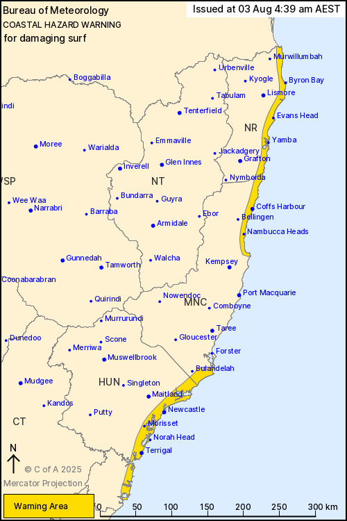
Damaging surf this weekend and early next week
Weather Situation: A weakening trough and low pressure system in the northeast of the state is bringing vigorous south to southeasterly winds and large, powerful easterly waves along the northern and central parts of the coast. A second low is developing near Gold Coast waters and will deepen during Sunday, bringing vigorous south to southeasterly winds and large, powerful southeasterly waves to northern NSW coasts before the low moves away to the east during Monday.
LARGE AND POWERFUL SURF CONDITIONS are likely, which may lead to coastal erosion and localised damage to coastal infrastructure between Broken Bay and Seal Rocks, including some Sydney beaches.
Beach conditions in these areas could be dangerous and people should stay well away from the surf and surf exposed areas.
These conditions are expected to ease during Sunday.
Locations which may be affected include Newcastle, Terrigal, Sydney, and Norah Head.
LARGE AND POWERFUL SURF CONDITIONS are likely, which may lead to coastal erosion and localised damage to coastal infrastructure between Seal Rocks and the Queensland border, developing from late Sunday afternoon.
Beach conditions in these areas could be dangerous and people should stay well away from the surf and surf exposed areas.
These conditions are expected to ease early Monday.
Locations which may be affected include Coffs Harbour, Tweed Heads, Byron Bay, Yamba, Evans Head and Nambucca Heads.
The State Emergency Service advises that people should:
- * Stay vigilant and monitor conditions.
- * For emergency help in floods and storms, ring your local SES Unit on 132 500.
Warnings are also available through TV and Radio broadcasts, the Bureau's website at www.bom.gov.au or call 1300 659 210. The Bureau and State Emergency Service would appreciate warnings being broadcast regularly.